
tangan:London Thames Sunset panorama - Feb 2008.jpg

pataayaway miazih hacica ku tabaki: 800 × 297 syangsu. u zuma katingalaw: 320 × 119 syangsu | 640 × 238 syangsu | 1,024 × 380 syangsu | 1,280 × 475 syangsu | 2,560 × 951 syangsu | 13,126 × 4,876 syangsu.
saayaway a tangan (13,126 × 4,876 syangsu, hacica ku tabaki nu tangan: 17.7 MB, MIME kakuniza: image/jpeg)
pecu’ nu lacul
| sapuelac |
العربية: صُورة پانوراميَّة من عدَّة مقاطع لأُفق لندن من على ضفَّة برموندساي لنهر التيمز.
Čeština: Podvečerní panorama Londýna
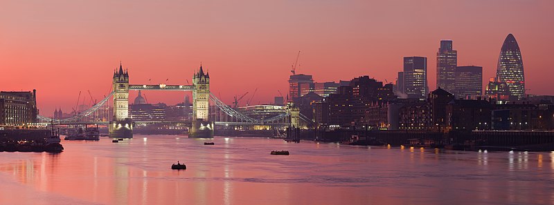
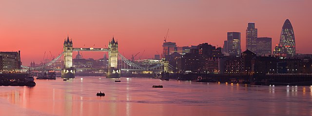
English: A multi segment panoramic image of the London skyline from the Bermondsey banks of the Thames, in which the Tower Bridge and 30 St Mary Axe are visible.
|
| demiad | 2008年tusa bulad (2008年tusa bulad18日, 根據EXIF的資料) |
| saangangan | numakuway a nalimaan |
| masacudaday | Diliff |
| pabeli tu kinli mahasa (patatenga’ tuyniyan a tangan) |
Summary:In using this image or any subsequent derivatives of it, you are required to release the image under the same license. As such, any reproduction of this image, in any medium, must appear with a copy of, or full URL of the license.Attribution of this image to the author (DAVID ILIFF) is also required, preferably in a prominent location near the image.No other conditions may be added to, or removed from this license without the permission of the author and copyright holder.Suggested attribution: "Photo by DAVID ILIFF. License: CC BY-SA 3.0"Please review the full license requirements carefully before using this image. If you would like to clarify the terms of the license or negotiate less restrictive commercial licensing outside of the bounds of GFDL/CC-BY-SA, please contact me by email, or if you don't have a Wikipedia account you can either leave a message on my talk page with your contact details and your request, or you can contact me on Facebook. Please also send a 'friend request' to ensure that I am aware of your message. |
| zuma a baziyong |
Derivative works of this file: |
| 拍攝地點 | | 位於此地的本圖片與其他圖片: OpenStreetMap |
|---|
|

.jpg)
This image was selected as picture of the day on Wikimedia Commons for 27 July 2012. It was captioned as follows: Other languages:
Русский: Панорама Лондона, столицы Олимпийских игр 2012 года മലയാളം : ലണ്ടൻ, 2012 ഒളിമ്പിക്സിന്റെ ആതിഥേയ പട്ടണം. |
sapabeli tu kinli a cedang
aku, tina nalimaan a nizaay nisanga’an tu tungus a kawaw, panutek sanu isasa’ay sapabeli tu kinli a cedang patiyak tina nalimaan

|
mapabeli tu kinli kisu sausipaybalucu’ zwanti kikingkay pahanhanan tu kamu, nuhkalan cudad atu saksak cudad GNU paybalucu’cudad sapabeli tu kinli a cedang 1.2 sapad haw u kilul tu nizateng palalid ku kawaw baziyong/sapad, miteka kopi kina tangan, yakayak haw misumad haw. kya matatelekay kopi silsilen ilabu nu GNU paybalucu’ cudad sapabeli tu kinli a cedang. |
此檔案採用創用CC 姓名標示 3.0 未在地化版本授權條款。
- kapah kisu paybalucu’:
- pasimel – kopi, patiyak atu yakayak tuyni nalimaan
- miliyaw miteka misumad – misanga’ lamit nu sapapelu nalimaan
- pikilulen nu isasaay a cudad:
- ngangan sacuzu’ – kanca kilulen nu misu masacudaday caay sa mahasa matuzu’ay sasakawawen sacuzu’ ngangan (amahicahica tu sasakawawen payni kisuan pisaungay tuyni nisanga’ay tu cudad sasakawawen sulit tu nakamuan nu tau).
kapah kisu mipili’ kaydihan isu sapabeli tu kinli a ceding.
tangan nu nazipa’an
sapecec ku demiad/tuki sapiciwsace ku tuki nina demiad a tangan baziyong
| demiad/tuki | sukep tu zunga | ditek | misaungayay | pacunus sakacaay kapawan | |
|---|---|---|---|---|---|
| ayza | 2015年5月19日 (sakatusa a demied nu lipay) 01:39 | 13,126 × 4,876(17.7 MB) | Diliff | fixed stitching error | |
| 2015年5月11日 (sakacacay a demied nu lipay) 01:26 | 13,126 × 4,876(17.63 MB) | Diliff | higher resolution version | ||
| 2008年3月1日 (sakaenem a demied nu lipay) 21:23 | 2,500 × 932(685 KB) | Diliff | {{Information |Description=A multi segment panoramic image of the London skyline from the Bermondsey banks of the Thames. Taken by myself with a Canon 5D and 70-200mm f/2.8L lens. |Source=self-made |Date=Feb 2008 |Author= Diliff |Permissio |
sakapaluwaluway nu tangan
isasaay kasabelih misiketkatukuh tina tangan:
sahamin-subal tangan pisaungay zasatu
isasa’ zuma Wiki masaungay tina tangan:
- ace.wikipedia.org ku pisaungay kalitemuhan kawaw
- af.wikipedia.org ku pisaungay kalitemuhan kawaw
- am.wikipedia.org ku pisaungay kalitemuhan kawaw
- ar.wikipedia.org ku pisaungay kalitemuhan kawaw
- نهر التمز
- مستخدم:ديفيد/صور ساهمت في جعلها مختارة
- بوابة:إنجلترا/صورة مختارة
- بوابة:إنجلترا/صورة مختارة/أرشيف
- ويكيبيديا:ترشيحات الصور المختارة/جسر البرج بلندن
- بوابة:إنجلترا/صورة مختارة/9
- ويكيبيديا:صور مختارة/أماكن/رؤية شاملة
- بوابة:أوروبا/صورة مختارة/أرشيف
- بوابة:أوروبا/صورة مختارة/8
- ويكيبيديا:صورة اليوم المختارة/يوليو 2015
- قالب:صورة اليوم المختارة/2015-07-14
- ويكيبيديا:صورة اليوم المختارة/سبتمبر 2016
- قالب:صورة اليوم المختارة/2016-09-21
- ويكيبيديا:صورة اليوم المختارة/يوليو 2018
- قالب:صورة اليوم المختارة/2018-07-10
- ويكيبيديا:صورة اليوم المختارة/يوليو 2021
- قالب:صورة اليوم المختارة/2021-07-05
- ast.wikipedia.org ku pisaungay kalitemuhan kawaw
- azb.wikipedia.org ku pisaungay kalitemuhan kawaw
- ban.wikipedia.org ku pisaungay kalitemuhan kawaw
- bcl.wikipedia.org ku pisaungay kalitemuhan kawaw
- be-tarask.wikipedia.org ku pisaungay kalitemuhan kawaw
- be.wikipedia.org ku pisaungay kalitemuhan kawaw
- bh.wikipedia.org ku pisaungay kalitemuhan kawaw
- bn.wikipedia.org ku pisaungay kalitemuhan kawaw
- bn.wikivoyage.org ku pisaungay kalitemuhan kawaw
- bo.wikipedia.org ku pisaungay kalitemuhan kawaw
- br.wikipedia.org ku pisaungay kalitemuhan kawaw
- bs.wikipedia.org ku pisaungay kalitemuhan kawaw
- crh.wikipedia.org ku pisaungay kalitemuhan kawaw
- cv.wikipedia.org ku pisaungay kalitemuhan kawaw
- cy.wikipedia.org ku pisaungay kalitemuhan kawaw
- da.wikipedia.org ku pisaungay kalitemuhan kawaw
- de.wikipedia.org ku pisaungay kalitemuhan kawaw
ciwsace kina tanganay a yadah pulungamin pisaungay tu zasatu.